BREAKING NEWS: Massive Hurricane Melissa Reaches Category 5 Strength — A Powerful Storm Leaves the Caribbean on Alert
A terrifying weather event unfolded across the Caribbean when Hurricane Melissa rapidly intensified into one of the most powerful hurricanes ever observed in the region. What began as a developing tropical system quickly transformed into a catastrophic Category 5 hurricane, bringing destructive winds, torrential rainfall, dangerous storm surge, flooding and landslides.
Hurricane Melissa formed over the Caribbean Sea in October 2025 after a tropical wave moved westward across the Atlantic. According to the European Centre for Medium-Range Weather Forecasts, the system became a tropical cyclone on October 21 and initially moved slowly. Conditions over the exceptionally warm Caribbean waters then allowed Melissa to strengthen dramatically.
The storm’s rapid intensification became one of the most alarming aspects of its development. Meteorologists observed Melissa becoming substantially stronger in a remarkably short period of time. By October 27, Hurricane Hunter aircraft had measured extremely powerful winds and a rapidly falling central pressure, confirming that Melissa had reached Category 5 intensity.
For residents in the storm’s path, the warnings became increasingly urgent.
A Category 5 Monster
Category 5 is the highest classification on the Saffir-Simpson Hurricane Wind Scale. Storms reaching this level have sustained winds of at least 157 miles per hour, making them capable of producing catastrophic destruction.
Melissa ultimately became far stronger than the minimum Category 5 threshold. The National Hurricane Center reported winds reaching 175 mph as the hurricane approached Jamaica on October 28, while another advisory recorded a minimum central pressure of 901 millibars.
The storm’s enormous energy came from a combination of atmospheric and oceanic conditions. Warm water supplied tremendous heat and moisture to the hurricane, while favorable atmospheric conditions allowed the storm to organize and intensify.
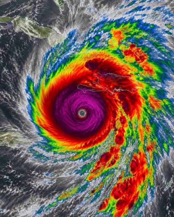
The result was a powerful, tightly organized hurricane with an extremely well-defined eye surrounded by a violent eyewall.
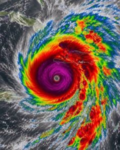
For people watching satellite images, Melissa’s appearance was unmistakable. A circular eye became surrounded by dense, towering thunderstorms, signaling the extreme intensity of the system.
Jamaica Faces the Worst of the Storm
The most serious impacts came when Melissa approached Jamaica.
The National Hurricane Center described the approaching storm as an extremely dangerous Category 5 hurricane and warned of catastrophic winds, flash flooding and storm surge.
On October 28, Melissa crossed western Jamaica. The combination of hurricane-force winds, heavy rainfall and storm surge created dangerous conditions across the island.
Homes and buildings faced severe wind damage. Electricity infrastructure was threatened. Roads became difficult or impossible to travel as water and debris covered transportation routes.
But wind was only one part of the danger.
Heavy rainfall can become especially destructive when a powerful hurricane moves slowly. Mountains and steep terrain can force moist air upward, producing even more rainfall. This can lead to flash floods and landslides, potentially isolating entire communities.
The Caribbean therefore faced multiple threats at the same time: extreme winds, coastal flooding, inland flooding, landslides and prolonged power outages.
Haiti and Other Caribbean Nations Also Affected
The danger did not stop at Jamaica.
Haiti, Cuba and the Dominican Republic also experienced significant effects from Melissa, including extreme rainfall and flooding. The World Meteorological Organization reported that Melissa caused devastating storm surge and damaging winds in Jamaica and Cuba, while extreme rainfall affected Haiti and the Dominican Republic as well.
In vulnerable areas, flooding can become deadly even when the center of a hurricane does not pass directly overhead.
Water can rise rapidly in rivers and low-lying neighborhoods. Landslides can occur on unstable slopes. Roads can be blocked by fallen trees, mud and debris. Emergency responders may also struggle to reach isolated communities.
That is why meteorologists repeatedly emphasize that a hurricane’s danger cannot be measured only by its maximum wind speed.
The Remarkable Strength of Melissa
Melissa shocked meteorologists because of how rapidly it intensified.
Reports later noted that the hurricane experienced extreme rapid intensification, gaining enormous strength over a relatively short period. Scientists studying the storm found that unusually warm ocean waters played an important role in supplying the energy needed for Melissa to become so powerful.
The storm eventually reached a peak intensity that placed it among the strongest tropical cyclones ever observed.
The National Hurricane Center documented an exceptionally low central pressure, while later analyses placed Melissa’s maximum sustained winds at approximately 185 mph at landfall.
Such numbers are difficult to comprehend from a human perspective. A hurricane of this strength contains an enormous amount of energy, and its eyewall can produce winds capable of destroying poorly constructed structures and severely damaging even stronger buildings.
A Storm That Will Be Remembered
The destruction caused by Melissa was so severe that the World Meteorological Organization eventually made an extraordinary decision: the name “Melissa” was retired from the Atlantic hurricane naming list.
The WMO announced in March 2026 that Melissa would never again be used for an Atlantic hurricane. The name was replaced by “Molly.” The organization cited the deaths and destruction associated with the storm.
This decision places Melissa alongside other infamous hurricanes whose names have been retired because of catastrophic consequences.
Retiring a hurricane name is more than a symbolic gesture. It reflects the scale of human suffering and destruction associated with the storm and ensures that the same name will not be reused in future Atlantic hurricane seasons.
A Reminder About Hurricane Preparedness
Melissa also demonstrated why preparation must begin before the worst conditions arrive.
Once hurricane-force winds begin, it may become too dangerous to travel. Roads can flood, bridges can become inaccessible, and emergency services may be overwhelmed.
Residents in hurricane-prone areas are encouraged to pay attention to official warnings, know their evacuation zones, prepare emergency supplies and have a communication plan for family members.
Emergency kits should generally include drinking water, food that does not require refrigeration, medications, flashlights, batteries, important documents and other essential supplies.
Most importantly, people should never underestimate a hurricane because the sky appears calm shortly before the strongest conditions arrive.
The Legacy of Hurricane Melissa
Hurricane Melissa was not simply another tropical storm. It became a historic Category 5 hurricane that demonstrated how quickly tropical systems can intensify under favorable conditions.
From its formation over the Caribbean to its explosive strengthening and devastating landfall in Jamaica, Melissa became a storm that meteorologists, emergency officials and communities will study for years.
The storm’s legacy also reinforces an important message: hurricanes are not just about wind.
Rainfall, storm surge, flooding, landslides and prolonged infrastructure failures can be equally dangerous.
The tragedy associated with Melissa ultimately led to the retirement of its name, ensuring that future generations will not experience another Atlantic hurricane officially called Melissa.
For those who lived through the storm, however, the name will remain more than a word on a weather map. It represents frightening nights, powerful winds, rising water, damaged homes, disrupted communities and lives forever changed.
Hurricane Melissa serves as a powerful reminder that nature can change rapidly and that preparation can make an enormous difference when extreme weather threatens.
When meteorologists issue warnings for a major hurricane, those warnings should never be treated as ordinary news. They can be the difference between being caught unprepared and reaching safety before conditions become life-threatening.